If you wish to contribute or participate in the discussions about articles you are invited to contact the Editor
EGNOS Space Segment: Difference between revisions
Carlos.Lopez (talk | contribs) No edit summary |
Gema.Cueto (talk | contribs) No edit summary |
||
| (21 intermediate revisions by 4 users not shown) | |||
| Line 4: | Line 4: | ||
|Level=Basic | |Level=Basic | ||
|YearOfPublication=2011 | |YearOfPublication=2011 | ||
|Logo=GMV | |||
|Title={{PAGENAME}} | |Title={{PAGENAME}} | ||
}} | }} | ||
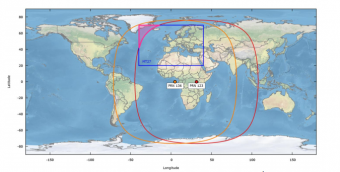
The EGNOS space segment is composed of | The EGNOS space segment is composed of four geostationary satellites (GEO) broadcasting corrections and integrity information for GPS satellites in the L1 frequency band (1575,42 MHz). The configuration of the GEOs in operation does not change frequently but possible updates are nevertheless reported to users by the EGNOS Service Provider. At the date of publication the 4 GEOs used by EGNOS over time are: | ||
[[File: | |||
* Inmarsat 3F2 AOR-E | PRN Number 120 | Orbital Slot 15.5 W | |||
* Astra Ses-5 | PRN Number 136 | Orbital Slot 5 E | |||
* Inmarsat 4F2 Emea | PRN Number 126 | Orbital Slot 64 E | |||
* Astra-5B | PRN Number 123 | Orbital Slot 31.5 E | |||
EGNOS GEO satellites SES-5 (PRN 136), ASTRE 5B (PRN 123) and INMARSAT 4F2 EMEA (PRN 126) are currently part of the EGNOS operational platform and are transmitting the operational Signal-In-Space (SIS) to be used by EGNOS users. On 1st January 2019 the INMARSAT 3F2 AOR-E (PRN 120) was decommissioned.<ref name = "EGNOS Service Notice"> [https://egnos-user-support.essp-sas.eu/new_egnos_ops/sites/default/files/documents/service_notice_20_0.pdf EGNOS Service Notice 20]</ref> From 23rd March 2020 onwards, PRN123 and PRN136 are operational while the PRN126 is in test mode.<ref name = "EGNOS Service Notice22"> [https://egnos-user-support.essp-sas.eu/new_egnos_ops/sites/default/files/documents/service_notice_22_0.pdf EGNOS Service Notice 22]</ref> | |||
This space segment configuration provides a high level of redundancy over the whole service area in case of a geostationary satellite link failure. The EGNOS operations are handled in such a way that, at any point in time, at least two GEOs broadcast an operational signal. Since it is only necessary to track a single GEO satellite link to benefit from the EGNOS Services, this secures a switching capability in case of interruption and ensures a high level of continuity of service. | |||
[[File:EGNOS_Coverage.png|Source: EGNOS Service Notice #22 <ref name = "EGNOS Service Notice22"> [https://egnos-user-support.essp-sas.eu/new_egnos_ops/sites/default/files/documents/service_notice_22_0.pdf EGNOS Service Notice 22]</ref> |340px|thumb|right]] | |||
It is intended that the EGNOS space segment will be replenished over time in order to maintain a similar level of redundancy. The exact orbital location of future satellites may vary, though this will not impact the service offered to users. Similarly, different PRN code numbers may be assigned to future GEOs. The PRN code changes will be explain in the future Service Definition Documents <ref name=" EGNOS Safety of Life Service Definition Document">[https://egnos-user-support.essp-sas.eu/new_egnos_ops/sites/default/files/documents/egnos_sol_sdd_in_force.pdf EGNOS Safety of Life Service Definition Document ]</ref> <ref name=" EGNOS Open Service Service Definition Document">[https://egnos-user-support.essp-sas.eu/new_egnos_ops/sites/default/files/documents/egnos_os_sdd_in_force.pdf EGNOS Open Service Service Definition Document]</ref> and in complementary EGNOS Service Notices. | |||
The foreseen new services will be made available from the provision of new signals from the last EGNOS transponders generation embarked on-board the SES-5 and ASTRA-5B geostationary satellites. Both satellites are capable of transmitting dual-frequency signals compliant with GPS L1/L5 and Galileo E1/E5 signal specifications (GPS L1/L5 and Galileo E1/E5 will be augmented by EGNOS V3 evolution), but L1-only signals were introduced into the EGNOS service provision.<ref>[http://www.gsa.europa.eu/news/gsa-kicks-egnos-geo-transponder-service-contracts GSA Kicks Off EGNOS GEO Transponder Service Contracts], GSA, November 27, 2014</ref> | |||
| Line 23: | Line 34: | ||
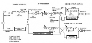
[[File:Inmarsat-3_Nav_Payload.JPG| Inmarsat-3 Navigation Payload block diagram |300px|thumb|right]] | [[File:Inmarsat-3_Nav_Payload.JPG| Inmarsat-3 Navigation Payload block diagram |300px|thumb|right]] | ||
Inmarsat’s Third Generation satellites carry a navigation payload which is used by EGNOS.<ref name=" The Inmarsat-3 | Inmarsat’s Third Generation satellites carry a navigation payload which is used by EGNOS, as can be seen in the Service Definition Document.<ref name=" EGNOS Open Service Service Definition Document">[https://egnos-user-support.essp-sas.eu/new_egnos_ops/sites/default/files/documents/egnos_os_sdd_in_force.pdf EGNOS Open Service Service Definition Document]</ref> | ||
The first Inmarsat-3 (F2 AOR-E) satellite carrying an EGNOS transponder was launched in September 1996 (PRN 120) while the second one, Inmarsat-3 F5 IOR-W, was launched in February 1998 (PRN 126). | |||
Inmarsat-3s were built by Lockheed Martin Astro Space (now Lockheed Martin Missiles & Space) of the USA, responsible for the basic spacecraft, and the European Matra Marconi Space (now Astrium), which developed the communications payload, being the first satellite launched by the Proton launch vehicle.<ref name=" Inmarsat Wikipedia Web site">[https://en.wikipedia.org/wiki/Inmarsat Inmarsat Wikipedia Web site]</ref> | |||
On 30th August 2018, the GEO satellite INMARSAT 3F2 (PRN120) became part of the EGNOS TEST Platform broadcasting the TEST SIS. On 1st January 2019, it ceased to broadcast EGNOS SIS and was totally removed from the EGNOS system<ref name=" EGNOS GEO Evolution">[https://egnos-user-support.essp-sas.eu/new_egnos_ops/sites/default/files/documents/service_notice_15.pdf EGNOS Service Notice 15 ]</ref>. | |||
==The Inmarsat-4 Satellite-Navigation Mission== | |||
Inmarsat’s Forth Generation satellites carry a navigation payload which is used by EGNOS. | |||
The first Inmarsat-4 (IOR) were built by EDAS Astrium and was launched in 11 March 2005 at orbital position 143, 5º East, using the Atlas V rocket. This satellite was launched with the intention of providing BGAN and GSPS services and also for bands wide rent. | |||
After that, a second satellite (AOR-West) was launched in 8 November 2005 at orbital position 53º West, in order to complement the BGAN and GSPS services aforementioned. The launch was made with a Proton-M/Briz-M rocket. | |||
Finally, the Third phase of Inmarsat-4 was launched in 18 August 2008 at orbital position 98º West, by a Proton rocket. <ref name=" European Geostationary Overlay Service">[https://en.wikipedia.org/wiki/European_Geostationary_Navigation_Overlay_Service European Geostationary Overlay Service ]</ref> | |||
==Astra Ses-5== | |||
Astra SES-5 is a commercial geostationary communication satellite operated by SES. It was launched on 9 July 2012 at orbital position 5º East. The launch was made with a Proton-M/Briz-M rocket from the Baikonur air base in Kazajistan. | |||
It was constructed by Space Systems/Loral, and is based on the LS-1300 satellite bus. The satellite is equipped with 24-C band (36MHz) and 36 Ku-band (33-36MHz) transponders. This satellite was born with the intention of improving the capacity for DTH (Direct to Home) and EGNOS services. | |||
The mission programmed duration is 15 years and the coverage area comprises of Sub-Saharan Africa, North Africa, Europe and Middle East Atlantic Ocean. | |||
==Astra-5B== | |||
[[File:Astra-5B.png| Astra-5B coverage |340px|thumb|right]] | |||
The Astra-5B satellite officially came into service in June 2014 at orbital position 31.5º East. The Astra 5B was launched into space on 22 March 2014. The launch was made with an Ariane 5 rocket from the Kourou air base in French Guiana. | |||
The satellite is equipped with 40 Ku-band transponders (equivalent to 36MHz) and 6 Ka-band transponders. In addition this new transponder will support the next EGNOS generation (EGNOS V3) that will provide dual-frequency signals on both bands L1 and L5 and augment both GPS and Galileo. <ref>[http://www.gsa.europa.eu/news/egnos-capability-and-service-enhanced-addition-new-generation-transponders EGNOS Capability And Service Enhanced With Addition Of New Generation Transponders], ESA, March 2014</ref> | |||
This satellite was born with the intention of improving the capacity for DTH (Direct to Home) services. Also for the capacity of cable services. They also feed digital terrestrial television networks in Central Europe, Eastern Europe and in particular Russia and neighbouring markets. | |||
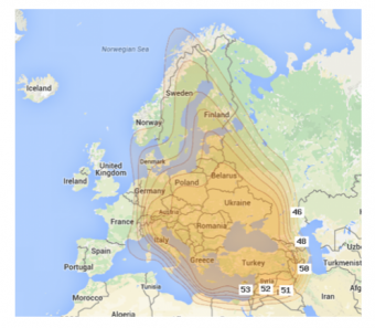
The Astra-5B was the 56th satellite in the SES fleet. It has two coverage beams, Wide and High Power. The High Power can be captured in the westernmost part of Europe, as can be seen in the image. <ref name=" Astra-5B High Powder coverage">[http://www.lyngsat-maps.com/footprints/Astra-5B-High-power.html Astra-5B High Power coverage]</ref> | |||
==Notes== | ==Notes== | ||
Latest revision as of 11:02, 18 March 2020
| EGNOS | |
|---|---|
| Title | EGNOS Space Segment |
| Edited by | GMV |
| Level | Basic |
| Year of Publication | 2011 |
The EGNOS space segment is composed of four geostationary satellites (GEO) broadcasting corrections and integrity information for GPS satellites in the L1 frequency band (1575,42 MHz). The configuration of the GEOs in operation does not change frequently but possible updates are nevertheless reported to users by the EGNOS Service Provider. At the date of publication the 4 GEOs used by EGNOS over time are:
- Inmarsat 3F2 AOR-E | PRN Number 120 | Orbital Slot 15.5 W
- Astra Ses-5 | PRN Number 136 | Orbital Slot 5 E
- Inmarsat 4F2 Emea | PRN Number 126 | Orbital Slot 64 E
- Astra-5B | PRN Number 123 | Orbital Slot 31.5 E
EGNOS GEO satellites SES-5 (PRN 136), ASTRE 5B (PRN 123) and INMARSAT 4F2 EMEA (PRN 126) are currently part of the EGNOS operational platform and are transmitting the operational Signal-In-Space (SIS) to be used by EGNOS users. On 1st January 2019 the INMARSAT 3F2 AOR-E (PRN 120) was decommissioned.[1] From 23rd March 2020 onwards, PRN123 and PRN136 are operational while the PRN126 is in test mode.[2]
This space segment configuration provides a high level of redundancy over the whole service area in case of a geostationary satellite link failure. The EGNOS operations are handled in such a way that, at any point in time, at least two GEOs broadcast an operational signal. Since it is only necessary to track a single GEO satellite link to benefit from the EGNOS Services, this secures a switching capability in case of interruption and ensures a high level of continuity of service.

It is intended that the EGNOS space segment will be replenished over time in order to maintain a similar level of redundancy. The exact orbital location of future satellites may vary, though this will not impact the service offered to users. Similarly, different PRN code numbers may be assigned to future GEOs. The PRN code changes will be explain in the future Service Definition Documents [3] [4] and in complementary EGNOS Service Notices. The foreseen new services will be made available from the provision of new signals from the last EGNOS transponders generation embarked on-board the SES-5 and ASTRA-5B geostationary satellites. Both satellites are capable of transmitting dual-frequency signals compliant with GPS L1/L5 and Galileo E1/E5 signal specifications (GPS L1/L5 and Galileo E1/E5 will be augmented by EGNOS V3 evolution), but L1-only signals were introduced into the EGNOS service provision.[5]
The main criteria followed in the selection of the satellites positions have been:
- Improve the measurement geometry and hence the system availability.
- Maximise the visibility angle diversity and hence minimise the risk of signal blocking.
- Provide dual geostationary coverage (minimum) within the core service area.
Inmarsat’s Third Generation satellites carry a navigation payload which is used by EGNOS, as can be seen in the Service Definition Document.[4]
The first Inmarsat-3 (F2 AOR-E) satellite carrying an EGNOS transponder was launched in September 1996 (PRN 120) while the second one, Inmarsat-3 F5 IOR-W, was launched in February 1998 (PRN 126).
Inmarsat-3s were built by Lockheed Martin Astro Space (now Lockheed Martin Missiles & Space) of the USA, responsible for the basic spacecraft, and the European Matra Marconi Space (now Astrium), which developed the communications payload, being the first satellite launched by the Proton launch vehicle.[6]
On 30th August 2018, the GEO satellite INMARSAT 3F2 (PRN120) became part of the EGNOS TEST Platform broadcasting the TEST SIS. On 1st January 2019, it ceased to broadcast EGNOS SIS and was totally removed from the EGNOS system[7].
Inmarsat’s Forth Generation satellites carry a navigation payload which is used by EGNOS. The first Inmarsat-4 (IOR) were built by EDAS Astrium and was launched in 11 March 2005 at orbital position 143, 5º East, using the Atlas V rocket. This satellite was launched with the intention of providing BGAN and GSPS services and also for bands wide rent. After that, a second satellite (AOR-West) was launched in 8 November 2005 at orbital position 53º West, in order to complement the BGAN and GSPS services aforementioned. The launch was made with a Proton-M/Briz-M rocket. Finally, the Third phase of Inmarsat-4 was launched in 18 August 2008 at orbital position 98º West, by a Proton rocket. [8]
Astra Ses-5
Astra SES-5 is a commercial geostationary communication satellite operated by SES. It was launched on 9 July 2012 at orbital position 5º East. The launch was made with a Proton-M/Briz-M rocket from the Baikonur air base in Kazajistan. It was constructed by Space Systems/Loral, and is based on the LS-1300 satellite bus. The satellite is equipped with 24-C band (36MHz) and 36 Ku-band (33-36MHz) transponders. This satellite was born with the intention of improving the capacity for DTH (Direct to Home) and EGNOS services. The mission programmed duration is 15 years and the coverage area comprises of Sub-Saharan Africa, North Africa, Europe and Middle East Atlantic Ocean.
Astra-5B
The Astra-5B satellite officially came into service in June 2014 at orbital position 31.5º East. The Astra 5B was launched into space on 22 March 2014. The launch was made with an Ariane 5 rocket from the Kourou air base in French Guiana. The satellite is equipped with 40 Ku-band transponders (equivalent to 36MHz) and 6 Ka-band transponders. In addition this new transponder will support the next EGNOS generation (EGNOS V3) that will provide dual-frequency signals on both bands L1 and L5 and augment both GPS and Galileo. [9] This satellite was born with the intention of improving the capacity for DTH (Direct to Home) services. Also for the capacity of cable services. They also feed digital terrestrial television networks in Central Europe, Eastern Europe and in particular Russia and neighbouring markets. The Astra-5B was the 56th satellite in the SES fleet. It has two coverage beams, Wide and High Power. The High Power can be captured in the westernmost part of Europe, as can be seen in the image. [10]
Notes
References
- ^ EGNOS Service Notice 20
- ^ a b EGNOS Service Notice 22
- ^ EGNOS Safety of Life Service Definition Document
- ^ a b EGNOS Open Service Service Definition Document
- ^ GSA Kicks Off EGNOS GEO Transponder Service Contracts, GSA, November 27, 2014
- ^ Inmarsat Wikipedia Web site
- ^ EGNOS Service Notice 15
- ^ European Geostationary Overlay Service
- ^ EGNOS Capability And Service Enhanced With Addition Of New Generation Transponders, ESA, March 2014
- ^ Astra-5B High Power coverage


