If you wish to contribute or participate in the discussions about articles you are invited to contact the Editor
GNSS Market Report: Difference between revisions
m (fixed broken link.) |
Paulo.Pombal (talk | contribs) No edit summary |
||
| (4 intermediate revisions by 2 users not shown) | |||
| Line 3: | Line 3: | ||
|Editors=GMV | |Editors=GMV | ||
|Level=Intermediate | |Level=Intermediate | ||
|YearOfPublication= | |YearOfPublication=2015 | ||
|Logo=GMV | |||
|Title={{PAGENAME}} | |Title={{PAGENAME}} | ||
}} | }} | ||
| Line 10: | Line 11: | ||
The underlying market model utilises advanced forecasting techniques applied to a comprehensive range of input data, assumptions and scenarios to forecast the size of the GNSS market in the European Union, North America and Rest of the World. Assumptions are informed by expert opinions and model results are cross-checked against the most recent market research reports from independent sources, before being validated through an iterative consultation process with sector experts and stakeholders.<ref>[http://www.gsa.europa.eu/news/gsa-market-report-promises-success-gnss GSA Market Report Promises Success For GNSS], European GNSS Agency (GSA), October, 2013</ref> | The underlying market model utilises advanced forecasting techniques applied to a comprehensive range of input data, assumptions and scenarios to forecast the size of the GNSS market in the European Union, North America and Rest of the World. Assumptions are informed by expert opinions and model results are cross-checked against the most recent market research reports from independent sources, before being validated through an iterative consultation process with sector experts and stakeholders.<ref>[http://www.gsa.europa.eu/news/gsa-market-report-promises-success-gnss GSA Market Report Promises Success For GNSS], European GNSS Agency (GSA), October, 2013</ref> | ||
The last report was published on | The last report was published on March 2015 and presents forecasts on specific GNSS market segments: Location-based services (LBS), Road, Aviation, Rail, Maritime, Agriculture, Surveying, Timing & Synchronisation. The report can be found in the [http://www.gsa.europa.eu/market/market-report GSA website]. | ||
==Report Overview== | ==Report Overview== | ||
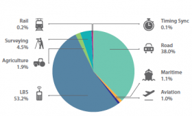
[[File: | [[File:market_report_2015_cumulative_core.png| Cumulative core revenue 2013-2023, GNSS Market Report 2015, GSA.|280px|thumb]] | ||
The first forecast is that the actual global installed base of GNSS devices of 3.6 billion units is predicted to grow to seven billion by 2019 – almost one GNSS receiver for every person on the planet (the previous market report expected this number to be reached only in 2022). The use of smartphones continues to dominate (3.08 billion in 2014), followed by devices for road applications (0.26 billion). | |||
At the regional level, the installed base in EU28 and North America will continue to grow steadily (8% per year). The primary region of global market growth will be Asia-Pacific, which is forecasted to grow 11% per year, from 1.7 billion in 2014 to 4.2 billion devices in 2023. The Middle East and Africa will grow at the fastest rate - 19% per year - but starting from a low base. | |||
LBS | ==Location-based services (LBS)== | ||
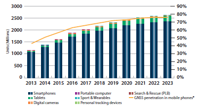
[[ | [[File:Market_report_2015_shipments_lbs.png|right|thumb|450px|LBS segment: Shipments of GNSS devices by platform]] | ||
Smartphones represent the vast majority of shipments, mainly due to their versatility and growig affordability. In 2013, smartphone shipments increased tenfold from 2007. | |||
Other GNSS-enabled devices accounted for more than 100 million units in 2013. Among them, tablets represented the second largest application. Their shipments increase 640% between 2010 and 2013, with major markets being Europe, North America and Asia. | |||
Finally, the wearable band market has exploded in the first half of 2014, with a 700% increase. High end devices feature assisted multi-constellation GNSS capabilities coupled with 3G or better connectivity. North America and Europe are the leading regions in shipments. | |||
Location Based Services rely on multiple location technologies, often combined with additional | |||
smartphone sensors. In fact, location data comes from: | |||
*handset-based technologies, such as GNSS, with computations performed mainly in the handset; | |||
*network-based technologies (e.g. Cell-ID, RF Pattern Matching and U-TDOA) with computations performed mainly in the network. | |||
Moreover, the advent of hybrid technologies such as A-GNSS and OTDOA - with intelligence in both the handset and the network - addresses user demand for access the location data in any environment. | |||
In this perspective, GNSS with other location technologies (accelerometer, gyroscope, compass) compliment each other, provide reliable location information augmented with data from sensors in the handset. | |||
The | The trend of integrating multiple GNSS constellations in smartphone chipsets started in 2011 with the emergence of the first GPS/GLONASS devices. The high penetration of GLONASS was supported by the announcement of a 25% tax on mobile phones imported to Russia without such capability. More recently, smartphones employing Galileo and BeiDou have also entered the market. | ||
==Road== | ==Road== | ||
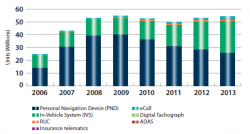
[[File: | [[File:market_report_2015_installed_base_road.png|right|thumb|250px|Road segment: Installed base of GNSS devices by application]] | ||
Since 2008, annual GNSS shipments worldwide have stabilised to 50 million units per year thanks to the success of navigation solutions, in particular Portable Navigation Devices (PNDs). | |||
which | In the last five years, smartphones had a disruptive impact on the PND market. This was in large part due to the improvement in GNSS receiver performance (e.g. AGNSS and multi-constellation), introduction of supporting technologies thanks to sensor fusion (e.g. dead reckoning), as | ||
well as the progressive increase in screen size and user friendliness of navigation apps for road navigation with pre-installed and self-updating maps. | |||
The decrease in PND sales has been compensated by the growth of In-Vehicle Systems (IVS) shipments, which experienced an average annual increase of 11% from 2009 to 2013. Such growth is motivated by the commercial opportunities offered by IVS as a platform, enabling navigation and connected vehicles, as well as many other GNSS-enabled services that meet user demand for comfort, infotainment and safety. | |||
A number of additional applications, including road user charging (RUC), insurance telematics and eCall, accounted for 3 million additional units shipped in 2013. | |||
Also, GNSS-based tolling is being increasingly adopted. With GNSS-based tolling, users can be charged based on different criteria (type of road, time, distance, vehicle type, level of emissions), all of which are easily modifiable over space and time. Other benefits of GNSS in complex new networks include low transaction costs, minimal environmental impact and additional revenues from value added services. At the end of 2014, the unique flexibility of GNSS enabled Slovakia to scale up GNSS-based tolling network operations in only three months, with its charged network increasing 7.5 times from 2,477 to 17,762 kilometres. | |||
Finally, the principle of GNSS positioning - with performances highly influenced by the conditions of the operational environment - and the need to ensure appropriate performance throughout the equipment’s lifetime, the development of standards and certification references on positioning | |||
performance is fundamental for device vendors and service providers, especially when it concerns safety-critical applications. | |||
The development of such standards will certainly have a positive impact on future road ITS industry developments, especially in regards to the need to provide industry with the highest practicable degree of uniformity in the provision and operation of GNSS services. | |||
Additionally, the automotive industry agrees on the future view of a sensors’ fusion, with GNSS as a core component, integrated into a car to provide enhanced positioning capabilities to be used with a plethora of innovative applications. | |||
==Aviation== | ==Aviation== | ||
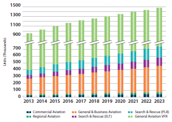
[[File: | [[File:market_report_2015_installed_base_aviation.png|right|thumb|350px|Aviation segment: Installed base of GNSS devices by segment]] | ||
GNSS | GNSS is included in all modern aircraft, whereas SBAS capable receivers are usually found as standard fit only in modern business and general aviation aircraft. | ||
General Aviation is the largest aviation sub-segment, with more aircraft and pilots than the business, regional, and commercial segments combined. The vast majority of these are located in North America. Sales in this segment are dominated by Visual Flight Rules (VFR) users who upgrade their devices more frequently to ensure they have the latest functionality or application. | |||
Due to the cost of devices certified for Instrument Flight Rules (IFR) use, most Commercial, Regional, and Business Aviation aircraft are retrofitted with enhanced avionics only once during the aircraft’s lifetime (often around 30 years). | |||
New for this year’s market report is the inclusion of Search and Rescue Emergency Locator Transmitters (ELTs) and Personal Locator Beacons (PLBs) into the chart data. The number of ELTs shipped is far exceeded by the PLBs. This is primarily due to the PLBs being used by smaller aircraft of less than six seats, which are much more numerous. Commercial, Regional and Business Aviation tend to be the prime target for ELTs. | |||
Shipments of IFR devices are expected to fall and plateau around the 15,000 per annum level, due to the increased equipage penetration of GNSS devices within an already strong market segment, with the retrofit market continuing to dominate the aviation market. | |||
Commercial Aviation is expected to continue using APV Baro approach procedures (at airports where ILS is not available) until Ground Based Augmentation Systems (GBAS) CAT II and CAT III become available, which should increase interest in retrofits. | |||
Future developments in equipment are expected to focus on the integration of multi-constellation and enable capabilities such as Advanced RAIM (A-RAIM), which uses two independent GNSS core constellations to monitor position integrity. | |||
The number of PLB devices shipped is expected to grow, continuing to exceed the number of ELT devices shipped. | |||
The major growth areas for Commercial Aviation will be Asia Pacific and Middle East and Africa. | |||
Also, Unmanned Aerial Vehicles (UAVs) are an emerging and promising market for GNSS in Aviation, thanks to their need for precise positioning and orientation. UAVs were initially used for military and security purposes. However, a wide range of civil applications will further drive market growth. | |||
GNSS developments in Aviation focus on enabling navigation applications, such as advanced Required Navigation Performance (RNP) and aerodrome manoeuvering, by leveraging multi-constellation/multi-frequency GNSS solutions. The technical requirements are being developed in this context to allow the aviation industry to benefit from improved integrity, accuracy and continuity. The transition to multi-constellation will also enable the introduction of Advanced Receiver Autonomous Integrity Monitoring (ARAIM), which will extend the benefits of LPV performances to those areas of the world not currently serviced by SBAS systems like EGNOS. | |||
==Rail== | ==Rail== | ||
[[File: | [[File:market_report_2015_shipments_app_rail.png|right|thumb|400px|Rail segment: Shipments of GNSS devices by application]] | ||
Introduction of rail applications must consider the constraints in the specific railway environment (e.g. limited satellite visibility, significant multipath or even electromagnetic interference). | |||
GNSS performance compliance to expected requirements for safety-relevant rail applications is being analysed. Accuracy and integrity requirements that are under development within UNISIG are expected to be very stringent. | |||
The use of GNSS should continue the growth in non-safety-relevant applications. Many rail freight cars, for which GNSS can be used for asset tracking, currently contain no power supply. Alternative solutions and their associated costs are being investigated first. | |||
Asset management applications are currently driving and expected to continue to drive shipments of GNSS devices. For the nearly 220,000 trains in the world dedicated to freight, the number of wagons with GNSS equipment is around 2.8 mln. | |||
In the coming years, safety-relevant applications (signalling and train control) based on GNSS will be increasingly developed. | |||
Despite the trend to include GNSS in safety-relevant applications, GNSS is currently used in non-safety-relevant ones, such as in passenger information and asset management, where technological innovation plays an important role. | |||
Due to upcoming market opportunities, the manufacturers are preparing to enter the railway signalling domain, which belongs within the realm of safety-relevant applications. | |||
==Maritime== | |||
The | [[File:market_report_2015_core_revenue_maritime.png|right|thumb|400px|Maritime segment: Core revenue from GNSS device sales by application]] | ||
In the Maritime segment, GNSS is employed to satisfy the demand for navigation and positioning of vessels and crews by different stakeholders. | |||
The e-Navigation initiative of the International Maritime Organization (IMO) aims to enhance the safety and ease of navigation by integrating all navigational tools in an all-encompassing bridge system. As e-Navigation systems should be resilient, they can drive the uptake of multi-constellation GNSS. | |||
The use of positioning in Maritime is widespread, with different categories of vessels, beacons and ports using GNSS for different purposes. | |||
The user needs and performance requirements of GNSS solutions depend heavily on the applications, designed to satisfy needs of improved safety and productivity. In this sense, accuracy and integrity are key for navigating in restricted waters as well as for positioning applications, as per IMO resolution A.915. | |||
There are around 29 million recreational vessels in use, whereas other crafts, including fishing vessels, are estimated to be around 3.3 million. This explains the relevance of GNSS shipments for recreational navigation, despite the fact that GNSS penetration is higher in merchant vessels than in recreational and fishing vessels (87% in merchant against 22% in recreational vessels and 8% in fishing | |||
vessels across all applications and globally). | |||
Aside from recreational navigation, Search & Rescue represents the most relevant market for GNSS. Since 2009, the shipments of Cospas-Sarsat GNSS-enabled emergency beacons stabilised at around 80,000 units per year. | |||
On fishing vessels, both Vessel Monitoring Systems (VMS) and Automatic Identification Systems (AIS) are used by national authorities to track and monitor the activities of their national fishing fleets. | |||
In the coming years, recreational vessels will be responsible for the further growth of GNSS yearly shipments, which will almost double from 1.15 million units in 2013 to 2.0 million in 2023. | |||
GNSS shipments for merchant navigation are expected to almost double in the next ten years, reaching some 50,000 units. | |||
GNSS has become the primary means of navigation in many Maritime applications. The IMO has set operational performance requirements for GNSS to | |||
be recognized as World-Wide Radio Navigation Systems (WWRNS). Those requirements are expressed in the maritime context in terms of accuracy, coverage, availability, continuity and integrity warnings. | |||
In order to ease the introduction of multi-GNSS receivers into the Maritime segment, the IMO “Maritime Safety Committee 90” introduced the need to develop new performance standards for navigation receivers. These new standards will enable full use of the availability, continuity and integrity, as well as increased accuracy, thanks to a combination of multi-constellation GNSS and terrestrial and augmentation systems. The status of the initiative is advanced and such standards are expected to be provided in the course of 2015. Anticipating the provision of standards, the adoption of multi-constellation in user equipment has already started. | |||
==Agriculture== | ==Agriculture== | ||
[[File: | [[File:market_report_2015_core_revenue_agriculture.png|right|thumb|400px|Agriculture segment: Core revenue from GNSS device sales by application]] | ||
Between 2006 and 2012, global shipments and the installed base of GNSS devices in the agriculture segment more than tripled. | Between 2006 and 2012, global shipments and the installed base of GNSS devices in the agriculture segment more than tripled. | ||
North America | North America is the most technologically advanced region, accounting for 57% of all GNSS devices in 2013. | ||
Asia-Pacific, which is made up of countries with very different agricultural features, is the fastest-growing region in terms of GNSS devices in use – from 0.3% of the total installed base in 2006 to 17% in 2013. | |||
Europe also experienced an increase in the installed base of GNSS devices, from 51,000 units in 2006 to 129,000 units in 2013. However, this growth has been at a slower pace than the rest of the world (14% per year). | |||
The most mature market is Australia. The increased efficiency provided by GNSS allows farmers there to address such challenges as water shortage and soil fertility, that affect many of Australia’s very large farms. | |||
From 2013 to 2023, annual shipments of GNSS devices are expected to increase more than fivefold. Overall, GNSS penetration is foreseen to experience a | |||
steady increase over the next decade, reaching 50% by 2023. Increasing competition, bargaining power of end users and economies of scale are all expected to contribute to a progressive decline in the average price of devices, with the effect of technological advancements only partially compensating price erosion. However, thanks to the sustained growth in GNSS device shipments, and in particular advanced applications, global revenues are expected to increase in all GNSS-enabled agricultural applications. | |||
Variable Rate Technologies will progressively gain momentum, with revenues increasing from €135 million in 2013 to €723 million in 2023. | |||
Likewise, revenues from Asset Management will grow from €11 million in 2013 to €102 million in 2023. | |||
Automatic Steering will generate the largest share of revenues and remain the most expensive application in terms of average price per device. However, it is also expected to experience the fastest price decrease, as high-accuracy applications will become increasingly available worldwide. Overall, revenues associated with Tractor Guidance are expected to peak in 2018, at which point they will begin to decline as farmers shift towards more advanced solutions. | |||
The integration of GNSS positioning in Farm Management Information Systems (FMIS), together with the use of additional information coming from various sensors, has revolutionised precision farming. Additional sensors can be used to enable remote sensing with additional information being provided by Earth Observation systems and meteorological stations. | |||
The emergence of more affordable, dual-frequency and multi-constellation receivers, as well as evolutions of PPP solutions, will further support precision farming – contributing, for example, to the improvement of GNSS-based machine auto guidance. | |||
==Surveying== | ==Surveying== | ||
[[File: | [[File:market_report_2015_core_revenue_surveying.png|right|thumb|400px|Surveying segment: Core revenue from GNSS device sales and service by application]] | ||
The installed base of GNSS devices has tripled over the past eight years, from 140,000 units in 2006 to 426,000 units in 2013. | |||
Asia-Pacific in particular experienced a substantial increase. In 2006, North America accounted for 44% of GNSS devices in use, but by 2013 this share had reduced to 30%. By contrast, Asia-Pacific has grown from 11% to 30% over the same time period. | |||
The growth in GNSS device shipments has been supported by Cadastral Surveying, Mapping and Construction (machine control) which, together, accounted for 87% of the installed base in 2013. | |||
The demand for cadastral surveys is partly the result of population and income growth in emerging countries and the application of the principle of fair taxation in established markets. | |||
Construction activities also played a significant role in fuelling growth, largely due to the construction boom in emerging markets and the post-crisis recovery in established ones. In 2013, the construction industry in Southeastern Asia grew 7.5%, compared to 4.5% increase in the United | |||
States and 4% in Japan, and a 2.5% decrease in Europe. | |||
Due to increasing competition and technological advancements, the average price of devices is expected to drop. Starting from 2020, price erosion and growth in shipments will compensate each other, stabilising total annual revenues. | |||
Growth in GNSS devices is expected to be driven by Cadastral Surveying and Construction activities. In 2023, surveying equipment for cadastral applications is expected to account for around half of the 500,000 shipments per annum. | |||
Machine control is foreseen to steadily increase over the next decade, with shipments growing from 35,000 units in 2013 to 155,000 in 2023. This activity can be considered a high value discipline as annual revenues will exceed €1 billion. | |||
==Timing & Synchronisation== | |||
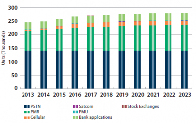
[[File:market_report_2015_devices_time_synchro.png|right|thumb|400px|Timing & Synchronisation segment: Installed base of GNSS devices by application]] | |||
This year's Market Report includes analysis of the Time & Synchronisation segment, restricted to Euro28 and Norway only. | |||
Precise Time and Synchronisation (Timing&Sync) is crucial to a range of strategic activities. This is especially the case for Critical Infrastructure (CI), a system or asset essential for maintaining such vital societal functions as health, safety, security, economic and social well-being of people. GNSS is often used to provide this Timing & Sync service in CI. | |||
In Satellite Communication (SATCOM), GNSS is used for TDMA (Time Division Multiple Access) timing on the satellite links and terrestrial links and NTP (Network Time Protocol) type services for IT/network/satellite monitoring/control. | |||
In Professional Mobile Radio (PMR) and Cellular Networks (Cellular), GNSS is used for the synchronisation of timeslots and for handovers between base stations. | |||
In Public Switched Telephone Networks (PSTN), GNSS is used as a backup in case timing information from atomic clocks is lost. GNSS reference time can be used for time of day, traffic timing and time slot management. | |||
Many telecom networks employ local oscillators that enable service to be temporarily maintained in case of GNSS loss. | |||
Network automatic protection of systems (Wide Area Measurement Systems/ Wide Area Control Systems) are using Phasor Measurements Units (PMUs) as a source of Timing&Sync information for Network Monitoring (current use) and Automatic Protection (future use). Automatic Protection requires a high level of accuracy and redundancy at PMU level. | |||
PMUs are deployed across remote locations of the power network (nodes), with internal time references currently based on GNSS receivers. | |||
Financial services rely on very powerful IT systems and networks requiring a high level of availability, security and reliability. GNSS is used for Synchronisation and Time Stamping functions to log events or quotes in a chronologic manner. There is a widespread use of transfer protocols like NTP/PTP to distribute time. | |||
The GNSS Timing&Synch segment is mainly driven by the Telecommunication sector, which represents around 90% of overall GNSS device shipments. | |||
With the upgrade of the Energy network, GNSS penetration is expected to reach 10% in 2017 (compared to 18% of GNSS overall penetration). GNSS Finance Timing&Sync is a mature market, where PTP is increasingly considered with an on-going research aimed at optimising its robustness. | |||
The GNSS installed base in the three segments (Telecom, Energy and Finance) in the EU28+Norway should reach 276,000 units in 2020, at which time it is expected to plateau. | |||
Rapid growth is expected in Mobile Cellular Networks with investment in 4G, reaching a peak in 2015/2016. | |||
Even if a smaller market size is expected for the Energy sub-segment, an important network upgrade is foreseen in the coming years as use of improved measurement and control systems (WAMS and WACS) is becoming widespread (smart grids) with a CAGR(2017-2023) of the GNSS installed base around 15%. | |||
==Previous Report Issues== | ==Previous Report Issues== | ||
The previous GNSS Market | The previous GNSS Market Reports can be found in the GSA Site: | ||
*[http://www.gsa.europa.eu/sites/default/files/GSAGNSSMarketreport2010.pdf GNSS Market Report Issue 1, 2010] | *[http://www.gsa.europa.eu/sites/default/files/GSAGNSSMarketreport2010.pdf GNSS Market Report Issue 1, 2010] | ||
*[http://www.gsa.europa.eu/sites/default/files/MarketReportMEP72012WEB.PDF GNSS Market Report Issue 2, 2012] | *[http://www.gsa.europa.eu/sites/default/files/MarketReportMEP72012WEB.PDF GNSS Market Report Issue 2, 2012] | ||
*[http://www.gsa.europa.eu/system/files/reports/GSA%20-Market%20Report%202013%20new_1.pdf GNSS Market Report Issue 3, October 2013] | |||
*[http://www.gsa.europa.eu/system/files/reports/GNSS-Market-Report-2015-issue4_0.pdf GNSS Market Report Issue 4, March 2015] | |||
==References== | ==References== | ||
Latest revision as of 18:38, 1 June 2015
| Applications | |
|---|---|
| Title | GNSS Market Report |
| Edited by | GMV |
| Level | Intermediate |
| Year of Publication | 2015 |
The European GNSS Agency (GSA) has been publishing with some regularity the GNSS Market Report on future trends for the Global Navigation Satellite System (GNSS) market[1]. The GSA report is already key references for companies and organisations to build their market strategies in relation to GNSS.
The underlying market model utilises advanced forecasting techniques applied to a comprehensive range of input data, assumptions and scenarios to forecast the size of the GNSS market in the European Union, North America and Rest of the World. Assumptions are informed by expert opinions and model results are cross-checked against the most recent market research reports from independent sources, before being validated through an iterative consultation process with sector experts and stakeholders.[2]
The last report was published on March 2015 and presents forecasts on specific GNSS market segments: Location-based services (LBS), Road, Aviation, Rail, Maritime, Agriculture, Surveying, Timing & Synchronisation. The report can be found in the GSA website.
Report Overview
The first forecast is that the actual global installed base of GNSS devices of 3.6 billion units is predicted to grow to seven billion by 2019 – almost one GNSS receiver for every person on the planet (the previous market report expected this number to be reached only in 2022). The use of smartphones continues to dominate (3.08 billion in 2014), followed by devices for road applications (0.26 billion).
At the regional level, the installed base in EU28 and North America will continue to grow steadily (8% per year). The primary region of global market growth will be Asia-Pacific, which is forecasted to grow 11% per year, from 1.7 billion in 2014 to 4.2 billion devices in 2023. The Middle East and Africa will grow at the fastest rate - 19% per year - but starting from a low base.
Location-based services (LBS)
Smartphones represent the vast majority of shipments, mainly due to their versatility and growig affordability. In 2013, smartphone shipments increased tenfold from 2007. Other GNSS-enabled devices accounted for more than 100 million units in 2013. Among them, tablets represented the second largest application. Their shipments increase 640% between 2010 and 2013, with major markets being Europe, North America and Asia. Finally, the wearable band market has exploded in the first half of 2014, with a 700% increase. High end devices feature assisted multi-constellation GNSS capabilities coupled with 3G or better connectivity. North America and Europe are the leading regions in shipments.
Location Based Services rely on multiple location technologies, often combined with additional smartphone sensors. In fact, location data comes from:
- handset-based technologies, such as GNSS, with computations performed mainly in the handset;
- network-based technologies (e.g. Cell-ID, RF Pattern Matching and U-TDOA) with computations performed mainly in the network.
Moreover, the advent of hybrid technologies such as A-GNSS and OTDOA - with intelligence in both the handset and the network - addresses user demand for access the location data in any environment.
In this perspective, GNSS with other location technologies (accelerometer, gyroscope, compass) compliment each other, provide reliable location information augmented with data from sensors in the handset.
The trend of integrating multiple GNSS constellations in smartphone chipsets started in 2011 with the emergence of the first GPS/GLONASS devices. The high penetration of GLONASS was supported by the announcement of a 25% tax on mobile phones imported to Russia without such capability. More recently, smartphones employing Galileo and BeiDou have also entered the market.
Road
Since 2008, annual GNSS shipments worldwide have stabilised to 50 million units per year thanks to the success of navigation solutions, in particular Portable Navigation Devices (PNDs). In the last five years, smartphones had a disruptive impact on the PND market. This was in large part due to the improvement in GNSS receiver performance (e.g. AGNSS and multi-constellation), introduction of supporting technologies thanks to sensor fusion (e.g. dead reckoning), as well as the progressive increase in screen size and user friendliness of navigation apps for road navigation with pre-installed and self-updating maps. The decrease in PND sales has been compensated by the growth of In-Vehicle Systems (IVS) shipments, which experienced an average annual increase of 11% from 2009 to 2013. Such growth is motivated by the commercial opportunities offered by IVS as a platform, enabling navigation and connected vehicles, as well as many other GNSS-enabled services that meet user demand for comfort, infotainment and safety. A number of additional applications, including road user charging (RUC), insurance telematics and eCall, accounted for 3 million additional units shipped in 2013.
Also, GNSS-based tolling is being increasingly adopted. With GNSS-based tolling, users can be charged based on different criteria (type of road, time, distance, vehicle type, level of emissions), all of which are easily modifiable over space and time. Other benefits of GNSS in complex new networks include low transaction costs, minimal environmental impact and additional revenues from value added services. At the end of 2014, the unique flexibility of GNSS enabled Slovakia to scale up GNSS-based tolling network operations in only three months, with its charged network increasing 7.5 times from 2,477 to 17,762 kilometres.
Finally, the principle of GNSS positioning - with performances highly influenced by the conditions of the operational environment - and the need to ensure appropriate performance throughout the equipment’s lifetime, the development of standards and certification references on positioning performance is fundamental for device vendors and service providers, especially when it concerns safety-critical applications. The development of such standards will certainly have a positive impact on future road ITS industry developments, especially in regards to the need to provide industry with the highest practicable degree of uniformity in the provision and operation of GNSS services. Additionally, the automotive industry agrees on the future view of a sensors’ fusion, with GNSS as a core component, integrated into a car to provide enhanced positioning capabilities to be used with a plethora of innovative applications.
Aviation
GNSS is included in all modern aircraft, whereas SBAS capable receivers are usually found as standard fit only in modern business and general aviation aircraft. General Aviation is the largest aviation sub-segment, with more aircraft and pilots than the business, regional, and commercial segments combined. The vast majority of these are located in North America. Sales in this segment are dominated by Visual Flight Rules (VFR) users who upgrade their devices more frequently to ensure they have the latest functionality or application. Due to the cost of devices certified for Instrument Flight Rules (IFR) use, most Commercial, Regional, and Business Aviation aircraft are retrofitted with enhanced avionics only once during the aircraft’s lifetime (often around 30 years). New for this year’s market report is the inclusion of Search and Rescue Emergency Locator Transmitters (ELTs) and Personal Locator Beacons (PLBs) into the chart data. The number of ELTs shipped is far exceeded by the PLBs. This is primarily due to the PLBs being used by smaller aircraft of less than six seats, which are much more numerous. Commercial, Regional and Business Aviation tend to be the prime target for ELTs.
Shipments of IFR devices are expected to fall and plateau around the 15,000 per annum level, due to the increased equipage penetration of GNSS devices within an already strong market segment, with the retrofit market continuing to dominate the aviation market. Commercial Aviation is expected to continue using APV Baro approach procedures (at airports where ILS is not available) until Ground Based Augmentation Systems (GBAS) CAT II and CAT III become available, which should increase interest in retrofits. Future developments in equipment are expected to focus on the integration of multi-constellation and enable capabilities such as Advanced RAIM (A-RAIM), which uses two independent GNSS core constellations to monitor position integrity. The number of PLB devices shipped is expected to grow, continuing to exceed the number of ELT devices shipped. The major growth areas for Commercial Aviation will be Asia Pacific and Middle East and Africa.
Also, Unmanned Aerial Vehicles (UAVs) are an emerging and promising market for GNSS in Aviation, thanks to their need for precise positioning and orientation. UAVs were initially used for military and security purposes. However, a wide range of civil applications will further drive market growth.
GNSS developments in Aviation focus on enabling navigation applications, such as advanced Required Navigation Performance (RNP) and aerodrome manoeuvering, by leveraging multi-constellation/multi-frequency GNSS solutions. The technical requirements are being developed in this context to allow the aviation industry to benefit from improved integrity, accuracy and continuity. The transition to multi-constellation will also enable the introduction of Advanced Receiver Autonomous Integrity Monitoring (ARAIM), which will extend the benefits of LPV performances to those areas of the world not currently serviced by SBAS systems like EGNOS.
Rail
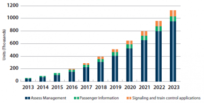
Introduction of rail applications must consider the constraints in the specific railway environment (e.g. limited satellite visibility, significant multipath or even electromagnetic interference). GNSS performance compliance to expected requirements for safety-relevant rail applications is being analysed. Accuracy and integrity requirements that are under development within UNISIG are expected to be very stringent. The use of GNSS should continue the growth in non-safety-relevant applications. Many rail freight cars, for which GNSS can be used for asset tracking, currently contain no power supply. Alternative solutions and their associated costs are being investigated first.
Asset management applications are currently driving and expected to continue to drive shipments of GNSS devices. For the nearly 220,000 trains in the world dedicated to freight, the number of wagons with GNSS equipment is around 2.8 mln. In the coming years, safety-relevant applications (signalling and train control) based on GNSS will be increasingly developed.
Despite the trend to include GNSS in safety-relevant applications, GNSS is currently used in non-safety-relevant ones, such as in passenger information and asset management, where technological innovation plays an important role. Due to upcoming market opportunities, the manufacturers are preparing to enter the railway signalling domain, which belongs within the realm of safety-relevant applications.
Maritime
In the Maritime segment, GNSS is employed to satisfy the demand for navigation and positioning of vessels and crews by different stakeholders. The e-Navigation initiative of the International Maritime Organization (IMO) aims to enhance the safety and ease of navigation by integrating all navigational tools in an all-encompassing bridge system. As e-Navigation systems should be resilient, they can drive the uptake of multi-constellation GNSS. The use of positioning in Maritime is widespread, with different categories of vessels, beacons and ports using GNSS for different purposes. The user needs and performance requirements of GNSS solutions depend heavily on the applications, designed to satisfy needs of improved safety and productivity. In this sense, accuracy and integrity are key for navigating in restricted waters as well as for positioning applications, as per IMO resolution A.915.
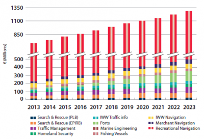
There are around 29 million recreational vessels in use, whereas other crafts, including fishing vessels, are estimated to be around 3.3 million. This explains the relevance of GNSS shipments for recreational navigation, despite the fact that GNSS penetration is higher in merchant vessels than in recreational and fishing vessels (87% in merchant against 22% in recreational vessels and 8% in fishing vessels across all applications and globally). Aside from recreational navigation, Search & Rescue represents the most relevant market for GNSS. Since 2009, the shipments of Cospas-Sarsat GNSS-enabled emergency beacons stabilised at around 80,000 units per year. On fishing vessels, both Vessel Monitoring Systems (VMS) and Automatic Identification Systems (AIS) are used by national authorities to track and monitor the activities of their national fishing fleets.
In the coming years, recreational vessels will be responsible for the further growth of GNSS yearly shipments, which will almost double from 1.15 million units in 2013 to 2.0 million in 2023. GNSS shipments for merchant navigation are expected to almost double in the next ten years, reaching some 50,000 units.
GNSS has become the primary means of navigation in many Maritime applications. The IMO has set operational performance requirements for GNSS to be recognized as World-Wide Radio Navigation Systems (WWRNS). Those requirements are expressed in the maritime context in terms of accuracy, coverage, availability, continuity and integrity warnings. In order to ease the introduction of multi-GNSS receivers into the Maritime segment, the IMO “Maritime Safety Committee 90” introduced the need to develop new performance standards for navigation receivers. These new standards will enable full use of the availability, continuity and integrity, as well as increased accuracy, thanks to a combination of multi-constellation GNSS and terrestrial and augmentation systems. The status of the initiative is advanced and such standards are expected to be provided in the course of 2015. Anticipating the provision of standards, the adoption of multi-constellation in user equipment has already started.
Agriculture
Between 2006 and 2012, global shipments and the installed base of GNSS devices in the agriculture segment more than tripled.
North America is the most technologically advanced region, accounting for 57% of all GNSS devices in 2013. Asia-Pacific, which is made up of countries with very different agricultural features, is the fastest-growing region in terms of GNSS devices in use – from 0.3% of the total installed base in 2006 to 17% in 2013. Europe also experienced an increase in the installed base of GNSS devices, from 51,000 units in 2006 to 129,000 units in 2013. However, this growth has been at a slower pace than the rest of the world (14% per year). The most mature market is Australia. The increased efficiency provided by GNSS allows farmers there to address such challenges as water shortage and soil fertility, that affect many of Australia’s very large farms.
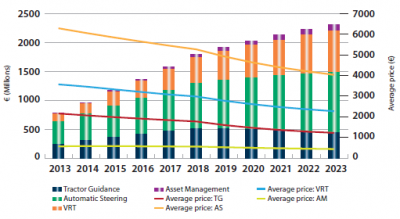
From 2013 to 2023, annual shipments of GNSS devices are expected to increase more than fivefold. Overall, GNSS penetration is foreseen to experience a steady increase over the next decade, reaching 50% by 2023. Increasing competition, bargaining power of end users and economies of scale are all expected to contribute to a progressive decline in the average price of devices, with the effect of technological advancements only partially compensating price erosion. However, thanks to the sustained growth in GNSS device shipments, and in particular advanced applications, global revenues are expected to increase in all GNSS-enabled agricultural applications. Variable Rate Technologies will progressively gain momentum, with revenues increasing from €135 million in 2013 to €723 million in 2023. Likewise, revenues from Asset Management will grow from €11 million in 2013 to €102 million in 2023. Automatic Steering will generate the largest share of revenues and remain the most expensive application in terms of average price per device. However, it is also expected to experience the fastest price decrease, as high-accuracy applications will become increasingly available worldwide. Overall, revenues associated with Tractor Guidance are expected to peak in 2018, at which point they will begin to decline as farmers shift towards more advanced solutions.
The integration of GNSS positioning in Farm Management Information Systems (FMIS), together with the use of additional information coming from various sensors, has revolutionised precision farming. Additional sensors can be used to enable remote sensing with additional information being provided by Earth Observation systems and meteorological stations. The emergence of more affordable, dual-frequency and multi-constellation receivers, as well as evolutions of PPP solutions, will further support precision farming – contributing, for example, to the improvement of GNSS-based machine auto guidance.
Surveying
The installed base of GNSS devices has tripled over the past eight years, from 140,000 units in 2006 to 426,000 units in 2013. Asia-Pacific in particular experienced a substantial increase. In 2006, North America accounted for 44% of GNSS devices in use, but by 2013 this share had reduced to 30%. By contrast, Asia-Pacific has grown from 11% to 30% over the same time period. The growth in GNSS device shipments has been supported by Cadastral Surveying, Mapping and Construction (machine control) which, together, accounted for 87% of the installed base in 2013. The demand for cadastral surveys is partly the result of population and income growth in emerging countries and the application of the principle of fair taxation in established markets. Construction activities also played a significant role in fuelling growth, largely due to the construction boom in emerging markets and the post-crisis recovery in established ones. In 2013, the construction industry in Southeastern Asia grew 7.5%, compared to 4.5% increase in the United States and 4% in Japan, and a 2.5% decrease in Europe.
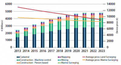
Due to increasing competition and technological advancements, the average price of devices is expected to drop. Starting from 2020, price erosion and growth in shipments will compensate each other, stabilising total annual revenues. Growth in GNSS devices is expected to be driven by Cadastral Surveying and Construction activities. In 2023, surveying equipment for cadastral applications is expected to account for around half of the 500,000 shipments per annum. Machine control is foreseen to steadily increase over the next decade, with shipments growing from 35,000 units in 2013 to 155,000 in 2023. This activity can be considered a high value discipline as annual revenues will exceed €1 billion.
Timing & Synchronisation
This year's Market Report includes analysis of the Time & Synchronisation segment, restricted to Euro28 and Norway only.
Precise Time and Synchronisation (Timing&Sync) is crucial to a range of strategic activities. This is especially the case for Critical Infrastructure (CI), a system or asset essential for maintaining such vital societal functions as health, safety, security, economic and social well-being of people. GNSS is often used to provide this Timing & Sync service in CI.
In Satellite Communication (SATCOM), GNSS is used for TDMA (Time Division Multiple Access) timing on the satellite links and terrestrial links and NTP (Network Time Protocol) type services for IT/network/satellite monitoring/control. In Professional Mobile Radio (PMR) and Cellular Networks (Cellular), GNSS is used for the synchronisation of timeslots and for handovers between base stations. In Public Switched Telephone Networks (PSTN), GNSS is used as a backup in case timing information from atomic clocks is lost. GNSS reference time can be used for time of day, traffic timing and time slot management. Many telecom networks employ local oscillators that enable service to be temporarily maintained in case of GNSS loss.
Network automatic protection of systems (Wide Area Measurement Systems/ Wide Area Control Systems) are using Phasor Measurements Units (PMUs) as a source of Timing&Sync information for Network Monitoring (current use) and Automatic Protection (future use). Automatic Protection requires a high level of accuracy and redundancy at PMU level. PMUs are deployed across remote locations of the power network (nodes), with internal time references currently based on GNSS receivers.
Financial services rely on very powerful IT systems and networks requiring a high level of availability, security and reliability. GNSS is used for Synchronisation and Time Stamping functions to log events or quotes in a chronologic manner. There is a widespread use of transfer protocols like NTP/PTP to distribute time.
The GNSS Timing&Synch segment is mainly driven by the Telecommunication sector, which represents around 90% of overall GNSS device shipments. With the upgrade of the Energy network, GNSS penetration is expected to reach 10% in 2017 (compared to 18% of GNSS overall penetration). GNSS Finance Timing&Sync is a mature market, where PTP is increasingly considered with an on-going research aimed at optimising its robustness. The GNSS installed base in the three segments (Telecom, Energy and Finance) in the EU28+Norway should reach 276,000 units in 2020, at which time it is expected to plateau. Rapid growth is expected in Mobile Cellular Networks with investment in 4G, reaching a peak in 2015/2016. Even if a smaller market size is expected for the Energy sub-segment, an important network upgrade is foreseen in the coming years as use of improved measurement and control systems (WAMS and WACS) is becoming widespread (smart grids) with a CAGR(2017-2023) of the GNSS installed base around 15%.
Previous Report Issues
The previous GNSS Market Reports can be found in the GSA Site:
- GNSS Market Report Issue 1, 2010
- GNSS Market Report Issue 2, 2012
- GNSS Market Report Issue 3, October 2013
- GNSS Market Report Issue 4, March 2015
References
- ^ GNSS Market Report, European GNSS Agency (GSA)
- ^ GSA Market Report Promises Success For GNSS, European GNSS Agency (GSA), October, 2013

