If you wish to contribute or participate in the discussions about articles you are invited to contact the Editor
WARTK Systems: Difference between revisions
m (Included editor logo.) |
|||
| (29 intermediate revisions by 5 users not shown) | |||
| Line 1: | Line 1: | ||
{{Article Infobox2 | {{Article Infobox2 | ||
|Category=Fundamentals | |Category=Fundamentals | ||
| | |Editors=GMV | ||
|Level=Basic | |Level=Basic | ||
|YearOfPublication=2011 | |YearOfPublication=2011 | ||
|Logo=GMV | |Logo=GMV | ||
|Title={{PAGENAME}} | |||
}} | }} | ||
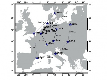
The Wide Area RTK (WARTK) concept was introduced in the late 1990s by the [http://www.gage.es/ Research Group of Astronomy and Geomatics (gAGE)] from the Technical University of Catalonia (UPC). The WARTK method increases the RTK/NRTK service area, with permanent stations separated by up to 500–900 kilometers. RTK reference stations should be of the order of ten km distance from rover, because the ionosphere produces ambiguity estimation biases that lead to positioning error above 1 meter. The main [[WARTK Fundamentals|WARTK techniques]] are related to an accurate real-time computation of ionospheric corrections, combined with an optimal processing of GNSS observables (carrier phases in particular) in both 2 and 3-frequency GNSS systems<ref>[http://www.gsa.europa.eu/wartk-based-egnos-and-galileo-technical-feasibility-study WARTK-EGAL Project]</ref>. Its potential use is in high-precision navigation/surveying applications. | |||
==WARTK Systems== | |||
Currently, the WARTK concept has been not developed as an operational system, although some projects have been carried out showing its feasibility.<ref>M. Hernandez-Pajares, et al, ''Real-time integrated water vapor determination using OTF carrier-phase ambiguity resolution in WADGPS networks'', Proceedings of the Institute of Navigation, pp. 616-625, Salt Lake City, UT, 2000.</ref><ref>M. Hernandez-Pajares, et al. ''Wide Area Real Time Kinematics with Galileo and GPS Signals'', Proceedings of the Institute of Navigation, Long Beach, California, 2004.</ref> | |||
[[File:WARTK2test.JPG|350px|thumb|WARTK-2 technique test in Europe.]] | |||
A typical implementation of a WARTK system could include the following components: | |||
*A Reference Stations Network (RSN), composed of a set of multi-frequency GNSS receivers covering the service area separated a few hundreds of kilometers away. For a region like Western Europe, a few tens of receivers would be enough. The system could take benefit of already deployed stations, provided they met the needed technical and environmental requirements. | |||
*A Central Processing Facility (CPF), connected to the reference station network with the capability to estimate the ionospheric correction with the required accuracy, and possibly with the function to re-distribute corrections from the reference stations to the users. | |||
*An Internal Communication Subsystem (ICS), connecting the reference station network and the Central Processing Facility. | |||
*A Broadcast Communication Subsystem (BCS), distributing the ionospheric corrections and the reference station data to the users. | |||
*User receivers, able to receive the data and to apply the corresponding algorithms, according to the corresponding Interface Control Document. | |||
The final profile and complexity of the system could be highly affected by key characteristics, such as the requested level of reliability, availability, security or safety. | |||
==Notes== | ==Notes== | ||
Latest revision as of 17:16, 18 September 2014
| Fundamentals | |
|---|---|
| Title | WARTK Systems |
| Edited by | GMV |
| Level | Basic |
| Year of Publication | 2011 |
The Wide Area RTK (WARTK) concept was introduced in the late 1990s by the Research Group of Astronomy and Geomatics (gAGE) from the Technical University of Catalonia (UPC). The WARTK method increases the RTK/NRTK service area, with permanent stations separated by up to 500–900 kilometers. RTK reference stations should be of the order of ten km distance from rover, because the ionosphere produces ambiguity estimation biases that lead to positioning error above 1 meter. The main WARTK techniques are related to an accurate real-time computation of ionospheric corrections, combined with an optimal processing of GNSS observables (carrier phases in particular) in both 2 and 3-frequency GNSS systems[1]. Its potential use is in high-precision navigation/surveying applications.
WARTK Systems
Currently, the WARTK concept has been not developed as an operational system, although some projects have been carried out showing its feasibility.[2][3]
A typical implementation of a WARTK system could include the following components:
- A Reference Stations Network (RSN), composed of a set of multi-frequency GNSS receivers covering the service area separated a few hundreds of kilometers away. For a region like Western Europe, a few tens of receivers would be enough. The system could take benefit of already deployed stations, provided they met the needed technical and environmental requirements.
- A Central Processing Facility (CPF), connected to the reference station network with the capability to estimate the ionospheric correction with the required accuracy, and possibly with the function to re-distribute corrections from the reference stations to the users.
- An Internal Communication Subsystem (ICS), connecting the reference station network and the Central Processing Facility.
- A Broadcast Communication Subsystem (BCS), distributing the ionospheric corrections and the reference station data to the users.
- User receivers, able to receive the data and to apply the corresponding algorithms, according to the corresponding Interface Control Document.
The final profile and complexity of the system could be highly affected by key characteristics, such as the requested level of reliability, availability, security or safety.
Notes
References
- ^ WARTK-EGAL Project
- ^ M. Hernandez-Pajares, et al, Real-time integrated water vapor determination using OTF carrier-phase ambiguity resolution in WADGPS networks, Proceedings of the Institute of Navigation, pp. 616-625, Salt Lake City, UT, 2000.
- ^ M. Hernandez-Pajares, et al. Wide Area Real Time Kinematics with Galileo and GPS Signals, Proceedings of the Institute of Navigation, Long Beach, California, 2004.

