If you wish to contribute or participate in the discussions about articles you are invited to contact the Editor
GLONASS Navigation Message: Difference between revisions
Carlos.Lopez (talk | contribs) No edit summary |
Carlos.Lopez (talk | contribs) No edit summary |
||
| (One intermediate revision by the same user not shown) | |||
| Line 1: | Line 1: | ||
{{Article Infobox2 | {{Article Infobox2 | ||
|Category=Fundamentals | |Category=Fundamentals | ||
|Authors=J. Sanz Subirana, JM. Juan Zornoza and M. Hernandez-Pajares, University of Catalunia, Spain. | |Authors=J. Sanz Subirana, JM. Juan Zornoza and M. Hernandez-Pajares, University of Catalunia, Spain. | ||
|Level=Basic | |Level=Basic | ||
|YearOfPublication=2011 | |YearOfPublication=2011 | ||
|Title={{PAGENAME}} | |||
}} | }} | ||
GLONASS satellites modulate two navigation messages at 50 bps onto the standard (C/A) and high accuracy (P) signals, each message providing the users the necessary information for positioning (parameters to compute GLONASS satellites coordinates, their clock offsets, and various other system parameters). | GLONASS satellites modulate two navigation messages at 50 bps onto the standard (C/A) and high accuracy (P) signals, each message providing the users the necessary information for positioning (parameters to compute GLONASS satellites coordinates, their clock offsets, and various other system parameters). | ||
Latest revision as of 10:15, 23 February 2012
| Fundamentals | |
|---|---|
| Title | GLONASS Navigation Message |
| Author(s) | J. Sanz Subirana, JM. Juan Zornoza and M. Hernandez-Pajares, University of Catalunia, Spain. |
| Level | Basic |
| Year of Publication | 2011 |
GLONASS satellites modulate two navigation messages at 50 bps onto the standard (C/A) and high accuracy (P) signals, each message providing the users the necessary information for positioning (parameters to compute GLONASS satellites coordinates, their clock offsets, and various other system parameters).
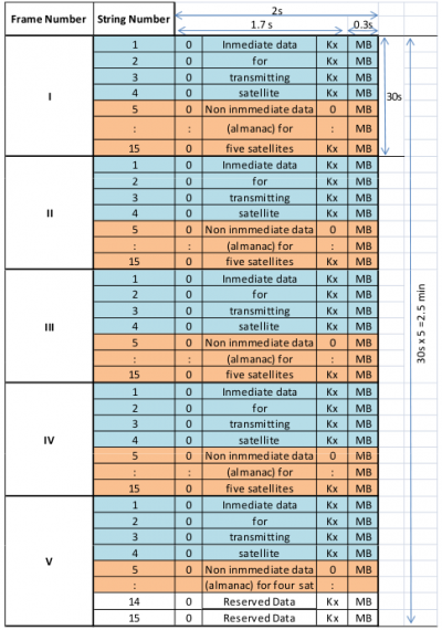
The navigation message of the standard accuracy signal (C/A) is broadcast as continuously repeating superframes with a duration of 2.5 minutes. Each superframe consists of 5 frames of 30 seconds, and each frame consists of 15 strings of 2 seconds duration (100 bits length).
The message content divides the data in immediate data of the transmitting satellite and non-immediate data for the other satellites. The immediate data is repeated in the first four strings of every frame. It comprises the ephemeris parameters, satellite clock offsets, satellite healthy flag and the relative difference between carrier frequency of the satellite and its nominal value. The non-immediate data is broadcast in the strings 5 to 15 of each frame (almanac for 24 satellites). The frames I to IV contain almanac for 20 satellites (5 per frame), and the 5th frame almanac for 4 satellites. The last 2 strings of frame 5 are reserved bits (the almanac of each satellite uses 2 strings).
The ephemerides values are predicted from the Ground Control Centre for a 24 hours period, and the satellite transmits a new set of ephemerides every 30 minutes. These data differ from GPS data. Instead of Keplerian orbital elements, they are provided as Earth Centred Earth Fixed (ECEF) Cartesian coordinates in position and velocity, with lunisolar acceleration perturbation parameters. The GLONASS-ICD [GLONASS ICD, 2008] provides the integration equations based on 4th-order-Runge-Kutta method, which includes the second zonal geopotential harmonic coefficient. The almanac is quite similar to the GPS one, given as modified Keplerian parameters, and it is updated approximately once per day.
The navigation message of the high accuracy signal (P) structure is not officially published, but different research groups decoded it. According with these investigations each satellite transmits a superframe, which is composed of 72 frames, each containing 5 strings of 100 bits. A frame needs 10 seconds to be transmitted, thence the total length of message is 12 minutes. The first three frames contain the ephemeris for the transmitting satellite.
Notes
References
- GLONASS ICD, 2008. Technical report. v.5.1.
- Hofmann-Wellenhof, B., Lichtenegger, H., K. and Wasle, E., 2008. GNSS - Global Navigation Satellite Systems.. Springer-Verlag, Wien, Austria.
- United Nations, 2004 Report of the action team on global navigation satellite systems (GNSS) – Follow up to the Third United Nations Conference on the Exploration and Peaceful Uses of Outer Space (UNISPACE III).

